
Essential Information
| Location |
National Maritime Museum
|
|---|---|
01 Jul 2013
Our item of the month looks at one of the most fascinating collections in the NMM Manuscript archives: portolan charts. Consisting of fifty-eight manuscript atlases and around fifty larger charts, the collection spans three centuries of navigational practice before mass-produced printed charts displaced them during the eighteenth century.
The precise definition of portolans varies but they share certain characteristics. To be considered a portolan, a chart must be a hand-drawn, original manuscript. Portolans are generally drawn on Vellum – animal skin that has been prepared for such use. This usually involved cleaning, bleaching and other treatments to prepare it for writing on. Our manuscript atlases (archive catalogue reference ‘P’), consist of charts drawn on vellum and then bound together. Many of our large unbound portolans, however, use one full-size skin or two joined together.
Portolan charts are a type of navigational sea chart, concerned with coastlines and ports, rather than features inland. They functioned primarily by judging the direction and distance between ports. A key feature of almost all portolans, therefore, is the compass rose. Sometimes known as the wind rose, this device depicted the eight directions of the winds (Tramontane, Greco/Grecale, Levante, Scirocco, Ostro/Mezzogiorno, Libeccio/Garbino, Ponente and Maestro/Mistral), later becoming known as the compass point directions (North, North-East, East, South-East, South, South-West, West and North-West). From these eight directions, radial lines known as Rhumbs were drawn. These lines were used to indicate the wind direction and best point of sailing for a vessel to reach a particular place on the chart. A vessel’s latitude could be calculated by using the sun and so many portolans, though not all, have latitude present. Other features include symbols for anchorage, depth soundings, sand banks and rocks.
Many of the portolans that have survived are astonishingly detailed and elaborately decorated. I spoke to our curator of Hydrography who explained that portolan charts were largely for trading voyages and therefore would have been regarded as disposable after they had served their purpose. Taken to sea, the charts would have become worn and ruined and so it would not have been economical to invest in an expensive, elaborately coloured chart. Hence many of the surviving charts are the heavily decorated and beautifully coloured portolans that would never have got wet or been used at sea but were produced for aesthetic purposes only, as a symbols of status and wealth. This helps explain why many of the surviving portolans do not have the Rhumbs drawn on and are preserved in such good condition.
Portolans began to disappear from the early eighteenth century, replaced by printed charts that cost far less to produce. The method of navigation portolans were created to serve, with the use of rhumbs and latitude, also vanished as chart-making expanded beyond mapping the Mediterranean. Whilst portolans are often striking beautiful, they were not accurate enough for longer voyages as they did not take into account the curvature of the earth. Nevertheless these charts were a vital navigational tool for our seafaring ancestors for over 400 years. Below are some examples of portolans from the NMM collections.
P/13
An early manuscript atlas, Buondelmonte’s portolan of 1420 is an Isolario or Island book of The Archipelago (Aegean Sea), covering the Ionian Islands, Aegean Islands and Constantinople. This is one of many copies of a prototype for many other Isolaria in the next 200 years. This Italian example is actually written on paper, but we have another copy on Vellum. It lacks many of the features shared by other portolans. Island books were often very basic because they were for local use only. Charts such as these were used by experienced seamen who already knew the area well, hence the lack of symbols denoting information such as where to anchor.
P/24(7) (top of screen)
This rather decorative chart depicting Persia is bound in a Venetian manuscript atlas made by Battista Agnese in 1554. Agnese would later correctly chart Baja, California, as a peninsula despite it still being depicted for many years as an island by other cartographers. On this particular chart, there is much iconography: the winds are depicted and labelled in Italian and German, one Portuguese and two Chinese ships are shown sailing the Indian Ocean and there are enthroned rulers. Trade and politics went hand-in-hand and a chart such as this suggests the need to consider whose waters were being navigated!
P/49(25)
P49/25: East part of Ulster, c.1525 Part of the Dartwood Collection of maps of Ireland, compiled for or by George Legge, Master General of the Ordnance, this chart shows the East part of Ulster and is dated ca. 1595. This chart is extensively decorated and rather interestingly, amongst the ships depicted there is also an oversized fish and a merman! For charts commissioned to be decorative, it is not uncommon to find such drawings. They serve both to draw the eye, balance the chart and fill the vast empty space where the seas lie. Devices such as these also served to pass on sea faring knowledge. What seems rather comical to us – an oversized fish – could represent a previous experience such as a whales in that area. Sea farers would often pass on their experience of traversing certain routes and this would influence chart makers, and also encourage their artistic leanings.
P/33(73)
The bay of Colan & port of Paita, 1685 This chart showing “The bay of Colan & port of Paita” is one of 149 charts bound in “A Waggoner of the South Sea describing the sea coast from Acapulco to Albermarle Isle, made by William Hack at the signe of great Britaine and Ireland in Wapping. Anno 1685”. William Hack made several copies of this atlas, this one being presented to James II! The atlas is based on stolen Spanish charts captured by the English buccaneer Captain Bartholomew Sharpe, amongst whose crew was Basil Ringrose who created his own ca. 1682 atlas “A Waggoner” (for more on Ringrose’s atlas, see our Library blog). Details of trading information would have been valuable at this time and this can be seen in the text accompanying the chart, “Paita from whence is transported aboundance of Corn & flower”. Hack’s chart features a coloured compass rose though only a few rhumbs have been drawn. The coastlines themselves are beautifully illustrated and coloured – fit for a King!
Larger charts:
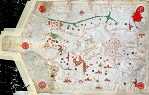
Mediterranean Sea and NE Atlantic, c.1456 Vibrantly coloured, this portolan chart depicts the Mediterranean Sea and North East Atlantic and was made by Jacopo Bertran and Berenguer Ripol in 1456. Drawn on a full skin of vellum, the chart features a compass rose with rhumbs drawn for the eight winds and also the eight half-winds, indicated by two different colours – green and red. Illustrations of various cities are present and the red sea is coloured red.
G213:2/4
Atlantic Ocean, Mediterranean and Black Sea, 1535 Attributed to Pedro or Jorge Reinel on stylistic grounds, this ca. 1535 chart of the North Atlantic includes coasts of parts of North and South America, Africa and Europe. Several compass roses, with accompanying rhumb lines, feature on the chart, which is drawn on two vellum skins joined and backed with paper. Coloured Illustrations of flags and castles are also featured.
Find out more about the NMM portolan charts by browsing the online Archive catalogue using the finding reference ‘P’ for our manuscript atlases here:
For larger portolans, browse our online charts and maps collection here:
Further books available in the Caird Library catalogue:
- The Sea Chart, Howse, D & Sanderson, M [Library ID: PBB2498]
- Portolan Charts and Atlases in the National Maritime Museum, Pflederer, Richard L. [Library ID: PBF7917]
- Finding their way at sea: the story of portolan charts, the cartographers who drew them and the mariners who sailed by them, Pflederer, Richard L. [Library ID: PBH5595]
Tara, Archive and Library