Essential Information
| Location |
Royal Observatory
|
|---|---|
30 Jul 2014
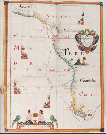
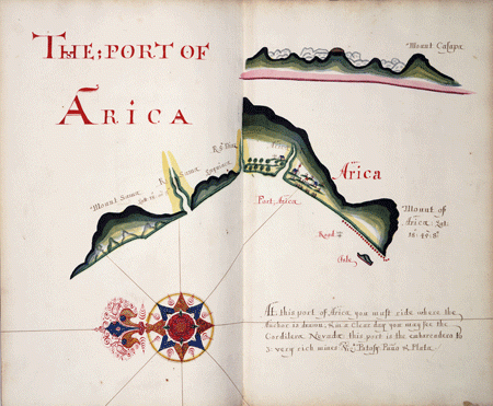
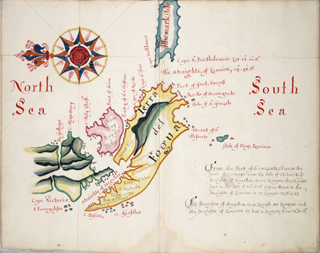
In this prize I took a Spanish manuscript of prodigious value. It describes all the ports, roads, harbours, bays, sands, rocks & rising of the land & instructions how to work a ship into any port or harbour between the Latt. of 17°15'N° [Acapulco] and 57° Latt [Cape Horn]. They were going to throw it over board but by good luck I saved it. The Spaniards cried when I got the book (farewell South Sea now).Since the sixteenth century the Spanish crown had controlled the production of sea charts of their overseas territories and strictly prohibited their circulation. The South Sea was thus largely uncharted territory for England and its seafarers, who had to rely on the often tentative and considerably less accurate charts of Dutch, French or English mapmakers. Bartholomew Sharp and several other buccaneers returned with their valuable catch to England in March 1682, but instead of selling the derrotero in London to the highest bidder, Sharp and two of his men found themselves arrested at the insistence of the Spanish ambassador, Don Pedro Ronquillo, and facing a trial for piracy at the High Court of Admiralty. Their attacks on Spanish ships and settlements had been undertaken without a legal commission and were in defiance of the Treaty of Madrid (1670), in which Spain recognised the English possession of Jamaica, while England agreed in return to respect the Spanish trading monopoly in their overseas territories and to suppress piracy. During the trial Sharp was strongly incriminated by the testimonies of two witnesses. The first was a Spanish ship boy from the Santa Rosario who reported how the English buccaneers attacked their ship, killed the captain, tortured the crew, and brought the boy as a prisoner to England. The other witness was an innkeeper from Wapping, who alleged that Sharp had been lodging at his inn and boasted that he had ‘lived a wicked course of life abroad’ and ‘had robbed all Nations, but especially the King of Spain’. Despite the peace treaty, considerable diplomatic pressure and the incriminating evidence from the two witnesses, Sharp and the other two defendants were mysteriously acquitted by the jury. As is usual for trials in this era, the reason for the acquittal is not recorded, but surviving correspondence between two English secretaries of state sheds an interesting light on the unexpected verdict. In June 1682, the Earl of Conway forwarded to his colleague Leoline Jenkins the king's instruction to delay the trial:
On some discourse between his Majesty and the Duke of Albemarle about the pirates in the South Sea, who are to be tried next Saturday, his Majesty commanded me late to-night to write to you to put off the trial till Wednesday or Thursday next, but so that it may give no umbrage or jealousy to the Spanish Ambassador, as if it were done by his Majesty's knowledge and direction, but by the direction of the court according to the rules of their proceeding. When you come here, his Majesty will acquaint you with the reason of it.Another letter, written two weeks earlier, reveals the reason for the crown's interference in the pirate trial – the derrotero of the South Sea:
The Spanish Ambassador told me he had delivered you the books lately taken from Capt. Sharpe, containing a description of the South Sea and Spanish seaports in cartes. His Majesty desires you to bring them with you, when you come next, with all the privacy you can and his Majesty, having received copies of those drafts, which are at present imperfect, will deliver them to you to get them perfected by that original with all possible secrecy.The Spanish maps then passed in secret into the hands of William Hack, a member of the Thames School of mapmakers who specialised in the production of manuscript sea charts. Hack had begun mapmaking in 1670 as an apprentice and quickly became one of the most productive mapmakers of his time. Between 1682 and 1696 he made at least 14 different copies of the 'South Sea Waggoner' (named after the Dutch mapmaker Lucas Waghenaer who published the first sea atlas of this kind in the sixteenth century), each using his trademark sign: an elaborate compass rose. The waggoner displayed in Ships, Clocks & Stars is one of two copies Hack presented to James II in 1685 and one of the most elegant copies he made. The other South Sea Waggoners were also handmade specifically for the admiralty and noble patrons, while the production of print copies was strictly prohibited to prevent the valuable knowledge from getting into the hands of other European nations. Whether any of Hack's South Sea Waggoners were used in subsequent English voyages to the Pacific is still debated by historians, but the dissemination of the maps among the political elite demonstrates the growing English interest in the South Seas and the role nautical knowledge played in their colonial schemes. What of the pirate trial? After his acquittal, Bartholomew Sharp was offered the command of a Royal Navy vessel, but turned the position down and returned to the Caribbean where he continued roaming and plundering the seas. Meanwhile, the Spanish ambassador in London, Don Pedro Ronquillo, protested about their acquittal to the king, who replied that ‘he did not meddle with matters relating to Law.’


