The anniversaries of several important naval events take place in late October. Today, 22 October, is the anniversary of one of the British Navy’s greatest tragedies – the Isles of Scilly shipwreck of 1707, in which four ships and over 1300 men were lost.
For the longitude story, and in particular the passing of the 1714 Longitude Act, the Isles of Scilly disaster has taken on particular importance in the last 50 years or so. Indeed, the catalogue of 4 Steps to Longitude, an exhibition at the National Maritime Museum in 1962, stated that the disaster ‘stirred public opinion; it was quoted as an illustration of the urgent need of a means to find longitude at sea, and contributed to the passing of the Act of 1714’. Other authors have followed suit in the decades since, often with more florid prose.
What I’m going to do over two posts is to look a little more closely at the connection between the 1707 disaster on the Isles of Scilly and the Longitude Act and think about two questions:
In this post - to what extent did the lack of a means of fixing longitude contribute to the disaster?
And in a second post - how significant was the tragedy in precipitating the 1714 Act?
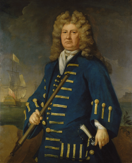
So let's start with the shipwreck. By 1707, Sir Cloudesley Shovell had a long and illustrious service career in the Royal Navy. He was Admiral of the Fleet and in command of operations in the Mediterranean, so had made the autumn journey back to England a number of times. Indeed, as early as May 1673, aged 23, he had been part of a fleet under Sir John Narborough that almost came to grief on the Isles of Scilly.
Sir Cloudesley Shovell, by Michael Dahl, about 1702-5 (NMM BHC3025)
Earlier that year, his ships had taken part in a failed attempt to take Toulon, and on 29 September Shovell decided to head home on his flagship, the Association, accompanied by 20 other navy vessels. It should have been a routine voyage in well-known waters, even though they hit gales as they headed northwards.
Just over three weeks later, Shovell ordered his ships to heave to and check their position by measuring the depth and sampling the seabed. This led them to believe that they were safely heading into the English Channel and could run eastwards before a favourable gale.
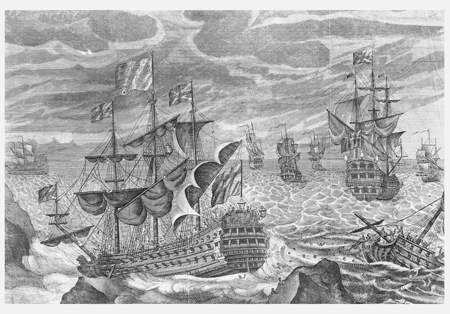
At about eight in the evening on 22 October, however, the crews on several of the ships spotted rocks and the glow of the St Agnes lighthouse. They were fast approaching the dangerous rocks and reefs surrounding the Isles of Scilly. The ships fired their guns as warnings, but the Association struck the Outer Gilstone Rock and soon sank. The Romney and Firebrand sank on the same rocks, while the Eagle went down off Tearing Ledge.
'Sir Cloudisly Shovel in the Association with the Eagle, Rumney and the Firebrand, Lost on the Rocks of Scilly, October 22, 1707' (NMM PAH0710)
Of the ships’ crews, only George Lawrence, quartermaster of the Romney, and 23 men from the Firebrand survived. Shovell was the most famous – and the most publicly mourned – of the casualties, but the death toll of over 1300 was huge. The Isles of Scilly disaster was the Navy’s greatest loss in a non-combat situation.
So what went wrong?
A plausible answer comes from W.E. May, who in 1960 analysed the navigation and possible causes of the loss of those four ships on the Isles of Scilly, by looking at 44 surviving log books from the vessels that made it home. Broadly speaking, he concluded that:
although the weather was poor for much of the voyage, observations for latitude were made by at least one officer on 15 of the 22 days, and the weather does not seem to have contributed significantly to the wreck
the Rennell Current may have contributed a little in placing the ships out of their expected position, but would not have been running strongly enough to have been a major factor
compass error, which was cited at the time by William Jumper of the Lenox, may also have contributed, in particular given the lack of allowance for variation given by any officers, but cannot have been the sole cause
May highlighted two things in particular that led to the disaster:
poor navigational practice by the officers. For instance, although latitude could be measured directly, there was still an average spread of 25½ miles in observed latitudes; the spread for latitudes from dead reckoning averaged 73 miles
inconsistent and incorrect data, including poor charts, and the fact that geographical data such as the longitude of places like Cape Spartel (from which many of the officers took their position) were not agreed upon, varying significantly according to which navigational manual one use
So, was longitude the cause? Analyses like May’s suggest that it was navigational uncertainty more generally, including poor basic data, which lay behind the wreck, and not simply the inability to fix longitude per se. In 1707, no-one singled out longitude determination as the definitive cause either. Better position-fixing techniques, including methods of finding longitude, could only have helped if combined with better observational practice by the ships’ officers and more accurate charts and geographical data.
In a second post, I’ll discuss what we currently believe about the role of the 1707 Isles of Scilly disaster with respect to the Longitude Act of 1714. Or if you’re in Greenwich tomorrow, I’ll be speaking about it as part of the Maritime Lecture Series devoted to longitude matters.
Some further reading:
W.E. May, ‘The Last Voyage of Sir Clowdisley Shovel’, Journal of Navigation, XIII (1960), pp. 324-332
Peter McBride and Richard Larn, Admiral Shovell’s Treasure (1999)