
Essential Information
| Location |
National Maritime Museum
|
|---|---|
18 Aug 2012
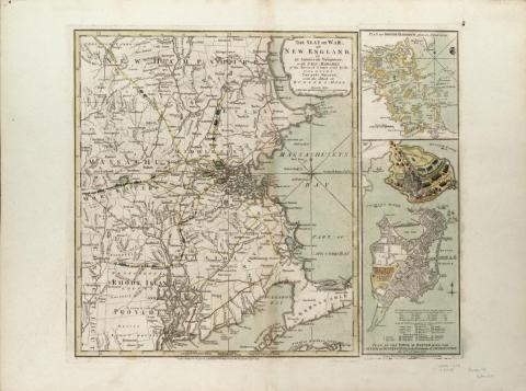
Our Item of the Month features printed charts and views of the Battle of Bunker Hill, from the chart and map collections.
Military plans and surveys provide the historical researcher with valuable information on different aspects of warfare. They record army and naval offensive and defensive positions and movements during battles and campaigns and also present details of the construction of forts and fortifications.
The National Maritime Museum holds in its chart, map and atlas collections a substantial amount of material related to various conflicts through the ages. Amongst these are the charts and plans associated with the late 18th century War of American Independence. The conflict is well represented in the North American atlases, maps and charts produced and published during that period by cartographers such as William Faden and the London firm of Sayer and Bennett.
The American Revolutionary War (by which the American colonists eventually gained Independence from Britain) originated from a series of disputes between Britain and its thirteen American colonies, mainly over taxation and trade issues. A series of unpopular measures, such as the Stamp Act of 1765 and Townshend Acts of 1767, were placed on the Americans by the British government. The resentment generated by this unrepresented taxation and the further custom duties subsequently imposed provoked civil action. This resistance was expressed in incidents such as the ‘Boston Massacre’ of 1770 and the famous ‘Boston Tea Party’ of 1773, when a group of men, disguised as native Americans, boarded three East India merchant ships moored in Boston Harbour and threw their cargoes of tea into the water.
The British responded by passing the Intolerable Acts in 1774. The port of Boston was closed, placed under military rule and garrisoned by regular troops and the colony of Massachusetts was also deprived of many of its government rights. Representatives of the thirteen colonies expressed their anger at the First Continental Congress at Philadelphia in 1774, and supported increased resistance against British rule.
The start of the American rebellion was finally provoked by the action of General Thomas Gage, the governor of Massachusetts, on 18 April 1775, when he dispatched a force of around 700 British soldiers to raid and capture an illegal arms and ammunition store located at Concord, a few miles outside Boston. The British troops were engaged and attacked by colonist militiamen on Lexington Common on 19 April 1775 and in the fighting there, and during the skirmishing that took place in the pursuit of the British back to Boston, both sides sustained casualties. The colonists lost 95 men killed and the British 275. The American colonists were soon strengthened by a large number of reinforcements and Boston was eventually surrounded by around 15,000 militiamen under General Artemus Ward and put under siege.
The Battle of Bunker Hill, 17 June 1775, was the first major engagement of the American Revolutionary War. General Thomas Gage’s besieged army in Boston had been reinforced by fresh British troops on 25 May 1775, under generals John Burgoyne, Henry Clinton and William Howe, providing him with a garrison force of about 7000 men. Learning of a possible British plan to occupy an area of strategic importance around the town, on 15 June 1775 the American commander General Artemus Ward ordered General Israel Putnam and Colonel William Prescott to lead an American force of around 1200 troops. Their aim was to seize and fortify Bunker Hill, the largest of three prominences on the peninsular overlooking Boston Harbour. On 16 June, the colonist soldiers occupied both Bunker and Breeds Hill, and Colonel William Prescott and his men constructed an earth redoubt or fort on Breeds Hill, the lower and more vulnerable of the two heights. American troops also took possession of Charlestown, a small village situated below the hills.
At dawn on 17 June 1775, British warships in the bay observed the American movements on the hills and the sixth rate HMS Lively (20 guns) opened fire on the fortifications. She was soon joined in the naval bombardment of the colonial positions by other vessels, including the sloop HMS Falcon (14 guns) and artillery fire from the battery on Copps Hill in Boston. After a council between the four British generals it was decided to launch an amphibious assault on Breeds and Bunker Hill. General Sir William Howe (later 5th Viscount Howe) commanded the British attack on the American positions, with Brigadier General Sir Robert Pigot acting as his second-in-command. They landed at Moultons Point with a force of 2200 regular soldiers, supported by naval fire, which set fire to Charlestown, which was evacuated by the defending Americans. The British twice launched attacks on the American fortifications and both times were met by close range fire and repulsed, forcing them to retreat with heavy casualties.
A third attempt was made to take the colonist positions and this time, with the aid of reinforcements, Howe’s fixed bayonet assault of Breeds Hill was successful and the place was captured. With most of their ammunition exhausted the Americans, although pursued by the British, withdrew in good order back from both Breeds and Bunker Hills, to either occupy new positions around Boston, or alternately returned to their original siege lines. The British suffered heavy losses during the Battle of Bunker Hill, losing about 228 men killed and 828 wounded. The American colonists sustained around 140 men dead and 271 wounded. Although considered a British victory, the favourable performance of the militiamen at Bunker Hill against regular British troops strengthened the rebel morale and resolve. The general situation was unchanged and the American siege of Boston continued unbroken until 13 April 1776, when the town was evacuated and finally captured by the American forces.
The illustrated printed and partially coloured map dated 1775 was constructed by Lieutenant Thomas Hyde Page and Captain (later Major) John Montresor, both engineers in the British army who served in America during the revolution. The map shows the area of the fighting above Charlestown. An attached paper flap records the troop positions of both sides in the battle on one plan, which when lifted reveals the action on Bunker Hill on a second plan. Also shown are the tracks of two of the Royal Navy warships (HMS Lively and HMS Falcon) involved in the bombardment of Charlestown and the American fortifications and the direction of their cannon fire.
The view by Lodge and Millar provides a dramatic picture of the fighting at the Battle of Bunker Hill on 17 June 1775. Charlestown can be seen in flames, after the bombardment of the Royal Naval ships lying off the peninsular while supporting the British attack on the American colonial positions on the heights.
The Second Continental Congress, at Philadelphia on 4 July 1776, issued and adopted a declaration of Independence from Britain. Although the war continued for another five years, with varying successes and setbacks on both sides, the surrender on 19 October 1781 of the besieged British Army under General Cornwallis at Yorktown virtually marked the end of the conflict. Peace negotiations commenced a year later in 1782, and at the Treaty of Paris on the 3 September 1783 American Independence was formally acknowledged and the United States of America was born.
Brian, Curator of Hydrography