

When American oceanographer and geographer, Dr Dawn Wright, embarked on a ten-hour voyage to the deepest known point of the ocean, she wasn’t nervous or scared – just excited.
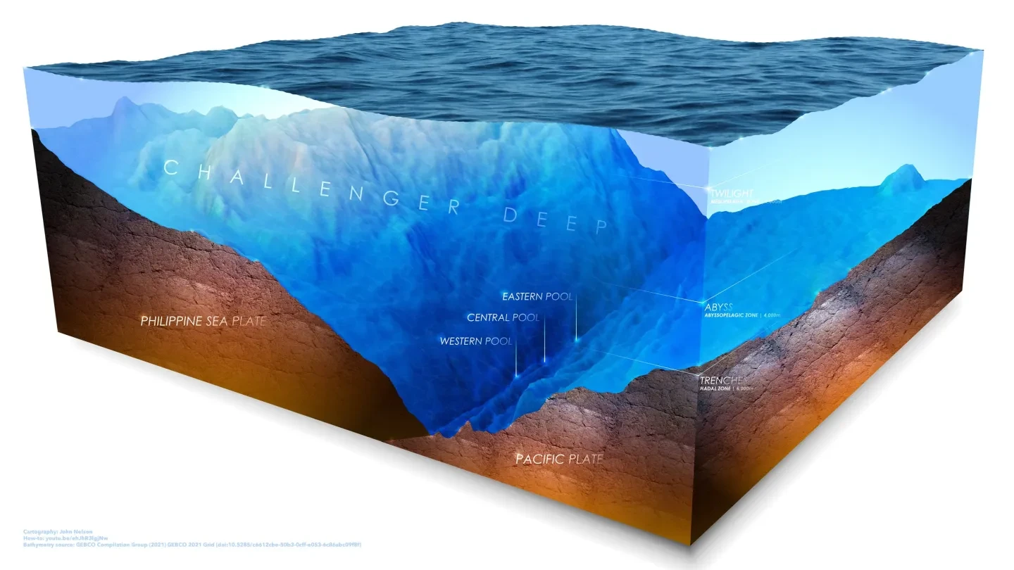
In July 2022, Dr Dawn journeyed to the depths of Challenger Deep in a submersible, as part of an initiative to map the area’s seafloor. Lying 10,935 metres below sea level, Challenger Deep is located at the southern end of the Mariana Trench in the western Pacific Ocean.
The record-breaking mission saw her become the first Black diver to have descended to Earth's deepest spot, an experience that she recounts in her book Mapping the Deep: Innovation, Exploration and the Dive of a Lifetime.
Known as ‘Deepsea Dawn’ to many, her drive and determination have made her one of the world’s leading environmentalists. Alongside her role as chief scientist of Esri – an organisation that makes geographic information system (GIS) software for mapping and spatial analysis – she manages a busy schedule of public engagements and academic work. She’s spoken at the 2025 UN Ocean Conference and is an award-winning professor of geography and oceanography at Oregon State University.
With a childhood spent in Hawaii, Dr Dawn’s love of the ocean began at an early age. She’s passionate about inspiring others to become involved in ocean conservation and science communication, sharing her experiences online. She also wants to encourage people to pursue their dreams and interests – which for her, also involves LEGO, cycling and spending time with her dog, Riley.
Here, she reveals what exploring the deepest part of the ocean was really like, from descending for hours in complete darkness to the sea life she encountered.
How did growing up in Hawaii shape your love of the ocean?
I decided to become an ocean scientist when I was eight years old. I was raised on a steady diet of oceanographer Jacques Cousteau’s television documentaries and would spend a lot of time in the ocean. But when I learned about the origin of the Hawaiian Islands – how they started on the bottom of the ocean and grew to breach the surface – I was fascinated.
I grew up in the 1960s, and there wasn’t a clear path to become an oceanographer. I ended up going to a small private liberal arts college and majoring in geology. From there, I went to Texas A&M University and got a master’s degree in oceanography, with a speciality in studying the seafloor and the geology of the oceans.
I then had a chance to live the dream of being at sea and being around science, as part of a three-year placement on the drilling vessel JOIDES Resolution of what was then known as the Ocean Drilling Program (it is now the International Ocean Discovery Program). I fell even more in love with ocean science and had the opportunity to help collect and process oceanographic data in the Southern Ocean, Indian Ocean, Pacific Ocean and the Atlantic Ocean.
After this, I went to the University of California, Santa Barbara and ended up with a dual PhD in geography and geology, with an emphasis on the ocean and GIS.
You've been on several research expeditions, including a record-setting mission to the East Pacific Rise. You've also spearheaded the use of GIS technology for seafloor mapping. What were the aims of the 2022 Challenger Deep expedition?
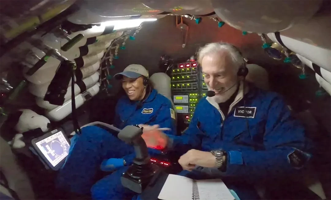
Challenger Deep is made up of three distinct depressions – the Western, Central and Eastern Pools – which are located in the Pacific Ocean’s Mariana Trench. The July 2022 expedition was piloted by Victor Vescovo, founder of research company Caladan Oceanic, and saw the two of us descend in the submersible Limiting Factor to the relatively unexplored Western Pool.
We wanted to test a prototype of a portable sidescan sonar, which would help us produce detailed images of the seafloor. Most of these instruments fail at depths of 6,000 metres due to the immense pressures of the ocean – let alone the maximum depth we achieved of 10,919 metres – so we wanted to see if we could get the instrument to function and collect data (which we did)!
Image
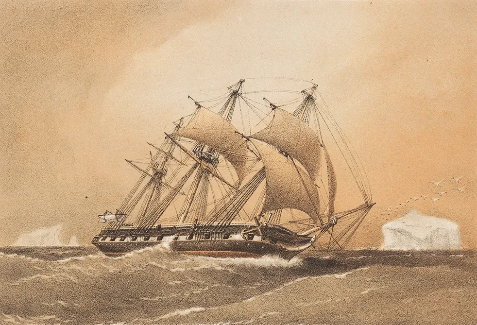
The history of Challenger Deep
The area takes its name from HMS Challenger – a research vessel that went on a global voyage of deep-sea exploration between 1872-76.
During the voyage, the expedition carried out oceanographic experiments, including deep-sea soundings and observations of currents, water temperatures, weather and surface ocean conditions.
How did you prepare for the Challenger Deep expedition?
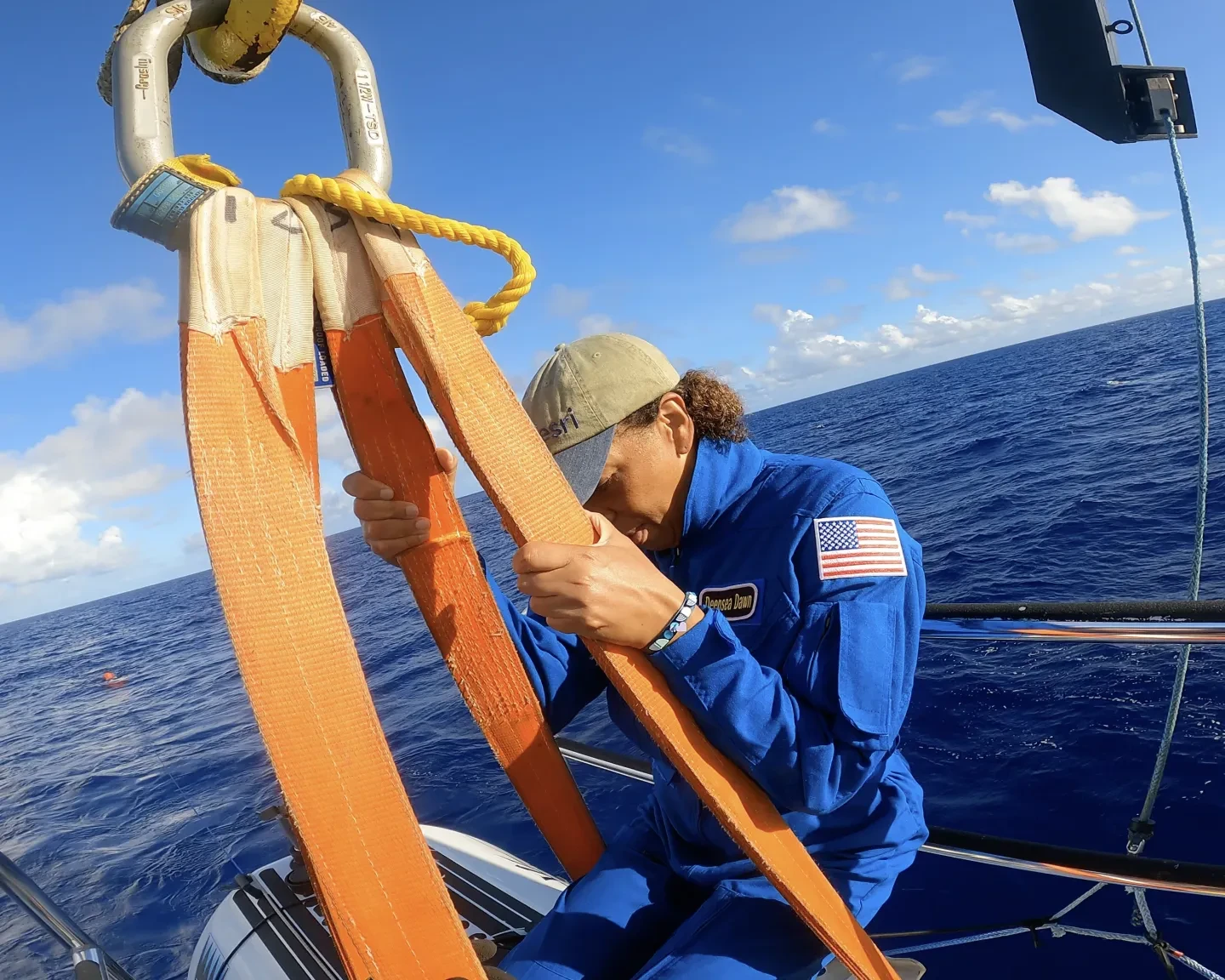
My role at Esri is office-based, so I no longer go to sea on a regular basis. I’m also in my 60s, and while I do keep fit and do lots of cycling, I felt it necessary to increase my flexibility and upper body strength. The Limiting Factor submersible is very confined, so I had to be able to hold my body weight, lower myself into the hatch and then pull myself out at the end.
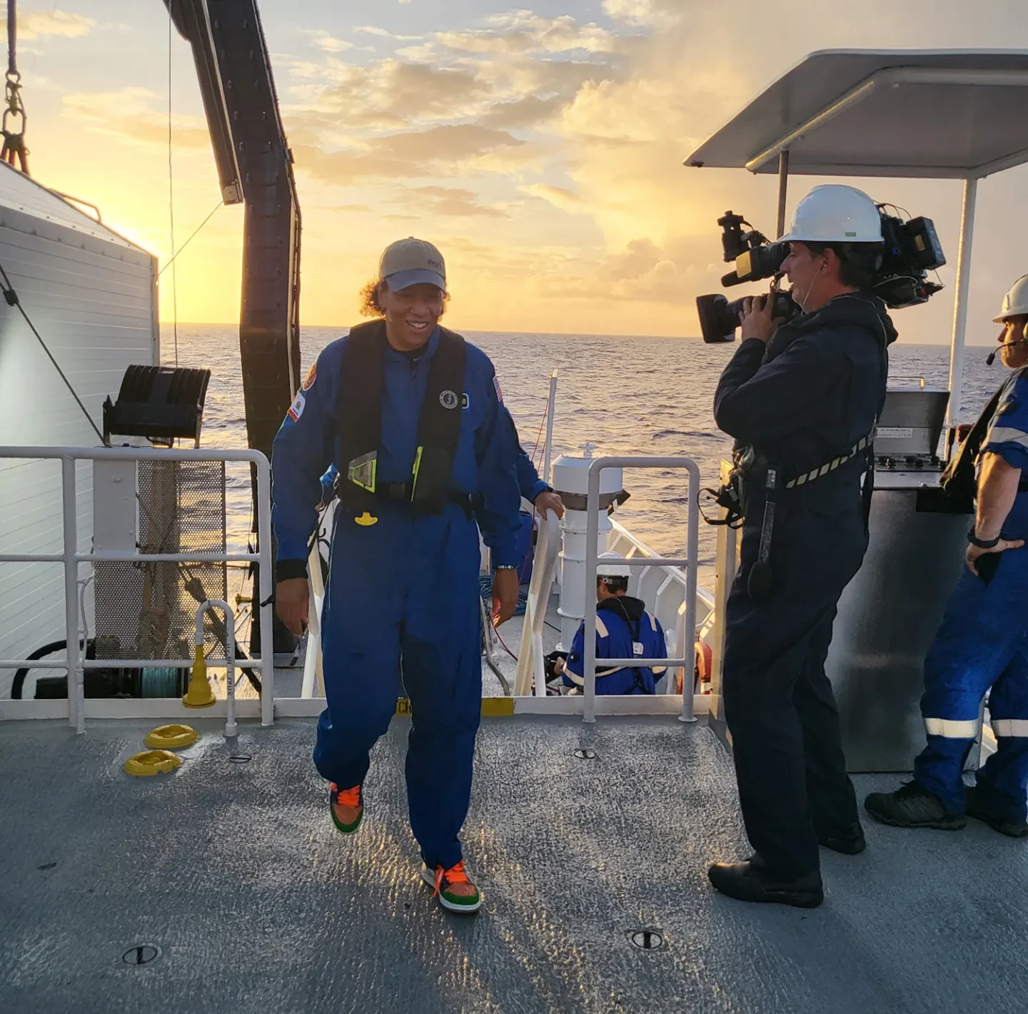
To get to Challenger Deep, I flew to Guam, an island in the Western Pacific Ocean. I then sailed for one-to-two days on the deep submergence support vessel (DSSV), Pressure Drop, which serviced and deployed the deep submergence vehicle (DSV) Limiting Factor.
The Challenger Deep dive was a ten-hour round trip, with no toilet inside the submersible. I had to slowly and carefully dehydrate myself leading up to the dive, reducing my food and drink intake. The day before, I received a full overview of the dive plan from my roommate Kate Wawatai, who was one of the technicians maintaining and supporting the Limiting Factor, and is now a record-setting submersible pilot in her own right.
I had done many submersible dives before, but none as significant as the Challenger Deep mission. I wasn’t scared or nervous, just very excited. I was completely knowledgeable of the operation, and confident that the people who were supporting it knew exactly what they were doing.
What was the descent like?
Descending into the ocean feels like going on a smooth, quiet elevator ride. It’s not at all like going into space where it’s very disruptive and you’re feeling all the G-forces. The Limiting Factor submersible is designed for ocean depth diving, so it slipped through the water very quickly.
The colours that I saw were amazing. You have the gorgeous aqua blue that you see in the lit part of the ocean – known as the ‘euphotic zone’ – that is home to lots of life, which slowly recedes to grey. After about 1,000 metres, the ocean is pitch black, almost like ink.
Most of the life in the ocean is thought to live 1,000-3,000 metres below sea level in the 'twilight zone.' These species communicate with each other in very different ways, such as bioluminescence – light produced by a living organism from a chemical reaction. During the descent, we saw bioluminescent jellyfish and siphonophores (worm-like organisms).
It took four hours to reach the bottom, and I brought some special items with me, including LEGO bracelets that I took down for a couple of little girls.
What did you see on the ocean floor?
The Mariana Trench is a collision zone between two tectonic plates: the Pacific plate and the Philippine plate, so the ocean floor was spectacular. We saw vast fields of angular blocks, home to creatures like anemones and hydroids.
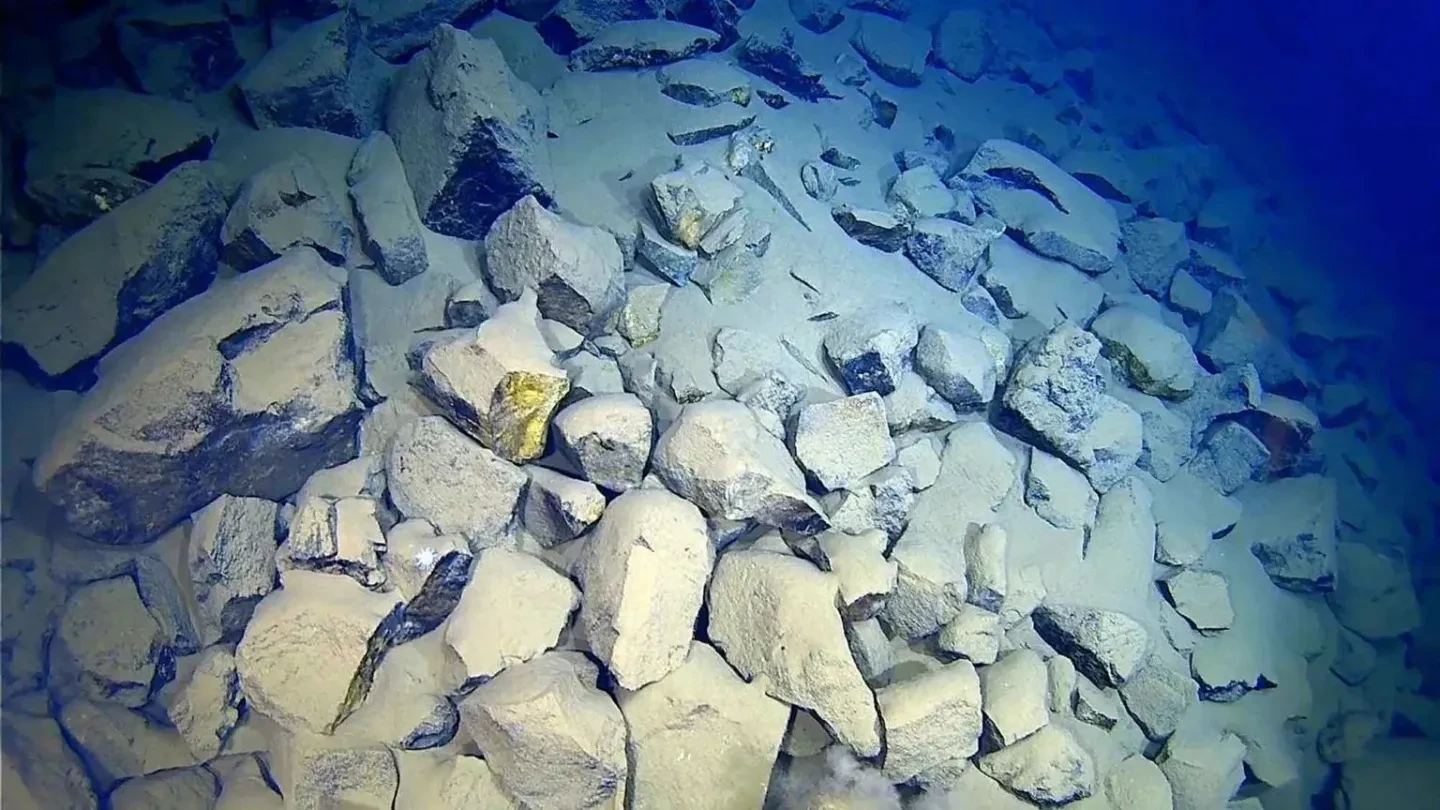
Our dive plan was to reach the bottom of the Western Pool, where we could carry out observations, test the prototype instrument and capture footage of the seafloor. The temperature of the seafloor was close to freezing, which meant that the temperature inside the submersible dropped to 40-45 Fahrenheit (around four-to-seven degrees Celsius).
We wore NASA flight suits throughout the mission, as these are fire retardant and kept us warm. I also wore a ‘Map the Gaps’ T-shirt – a nod to the community non-profit that is one of many organisations taking part in Seabed 2030. This UN programme seeks to map the global seafloor in detail by 2030.
Overall, the expedition in July collected four terabytes of data, including high-resolution videography of the Western Pool. The data has been given to Seabed 2030 and ArcGIS's Living Atlas of the World, which brings together geographical information from around the globe.
After two-and-a-half hours on the ocean floor, we began our ascent. This involved discarding several biodegradable concrete weights, which were subsumed into the seabed.
More than 80 per cent of the ocean remains unmapped. Why is this the case?
The ocean is a very difficult environment to map because of the water. In space, you can use electromagnetic energy, such as light, which can travel through Earth’s atmosphere. However, electromagnetic energy doesn’t penetrate the surface waters of the ocean very deeply.
Instead, we need to mimic the communication systems of species such as dolphins and whales and use acoustic energy. 70 per cent of the Earth is made of water and acoustic energy travels much more effectively and efficiently through the ocean. To measure the depth of the ocean (bathymetry), we measure the travel time of calls or pings to and from the seabed.
We can also use mapping to enhance our knowledge of climate patterns. The ocean plays a critical role in regulating the Earth’s climate. Through mapping, we can understand how heat circulates: not just at the surface, but all the way through the different depths of the ocean – and how this interacts with our atmosphere and drives the temperatures we experience on land.
Another use of mapping is to monitor marine life stocks and to help address illegal and unregulated fishing – including the fishing of species that live on the seafloor. Around 95 per cent of our internet data and traffic are relayed through submarine cables, so we need to understand the intricacies of the ocean floor to maintain and expand this vast network.
You're passionate about encouraging others to become involved in ocean conservation and STEM. How important is it for women to see themselves represented in these areas?
When tackling issues like ocean conservation, we need to ensure we have a variety of perspectives, so we can bring together the best ideas, generate solutions and move forward. But how can we do this if we're not including half of the human population, which is the female perspective?
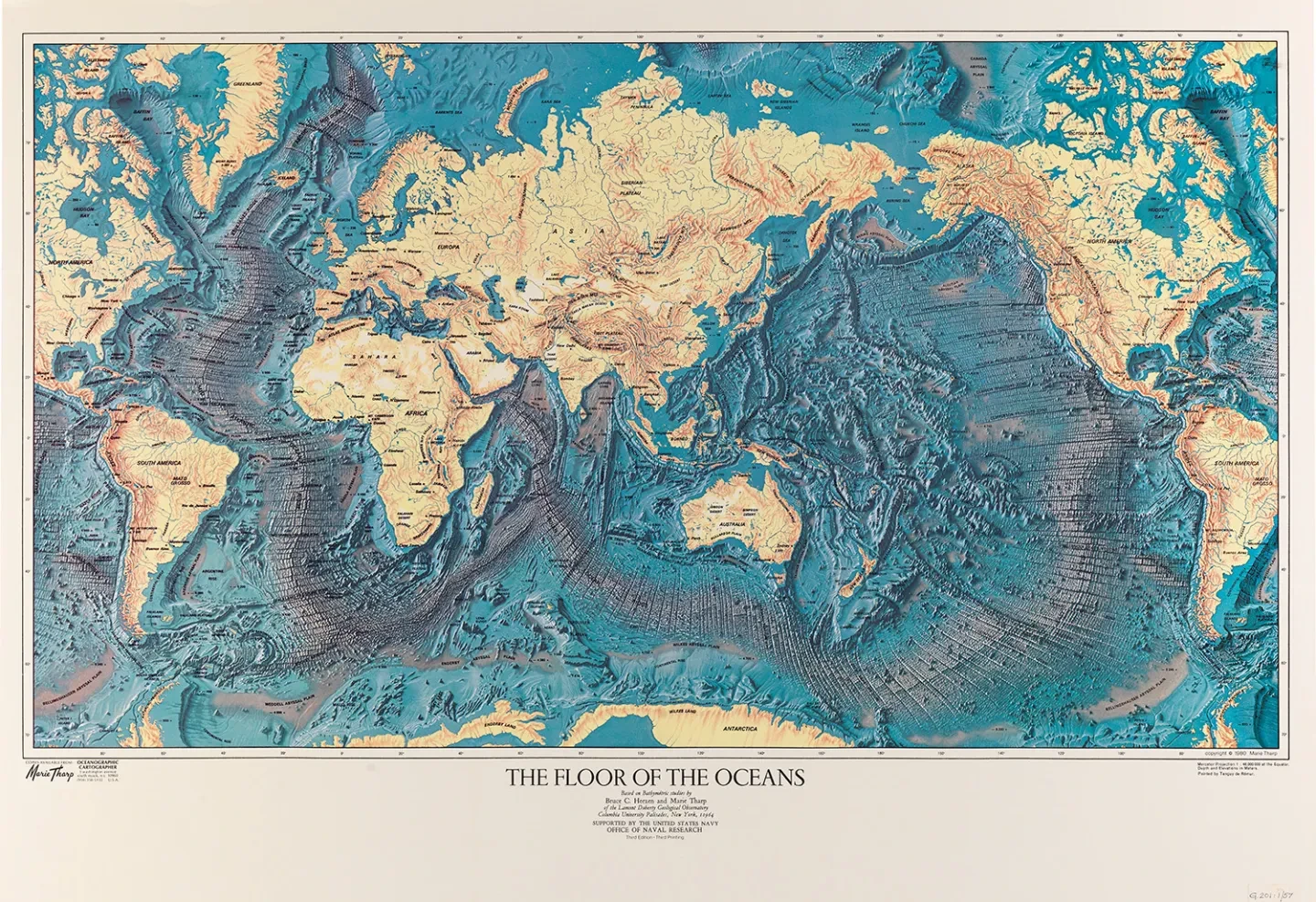
One of the guiding lights in my career has been Marie Tharp, who helped to establish the discipline of marine cartography. Between the 1950s-70s, she worked with scientist Bruce Heezen to create a series of beautiful maps of the ocean floor. The discoveries she made while creating these, such as the rift valley in the Mid-Atlantic Ridge, helped to spur on the plate tectonics revolution.
Another scientist I admire is Cassie Bongiovanni, who is a couple of generations younger than I am. Cassie was the lead mapper on Victor Vescovo’s 'Five Deeps' initiative, which made dives to the deepest known points in all five of the world's ocean basins. She helped to locate these five deepest spots so that Victor could dive on them, as well as mapped eight trenches in the Ring of Fire, a belt of volcanoes in the Pacific Ocean. Cassie is in the prime of her career.
Expeditions like these, where women have been able to lead or participate, are very important. The message this sends – and what it represents – is extremely powerful: young people and children can see that everyone can participate in these activities, and everyone has something to contribute.

Making Waves
Stories of incredible women working at sea
Find out more
Image: © Inka Cresswell
Dive deeper


Banner image: Dr Dawn Wright climbing out of the Limiting Factor submersible. Image courtesy of Caladan Oceanic and Esri
Our partners
With grateful thanks to The TK Foundation for its support of the Making Waves series.