
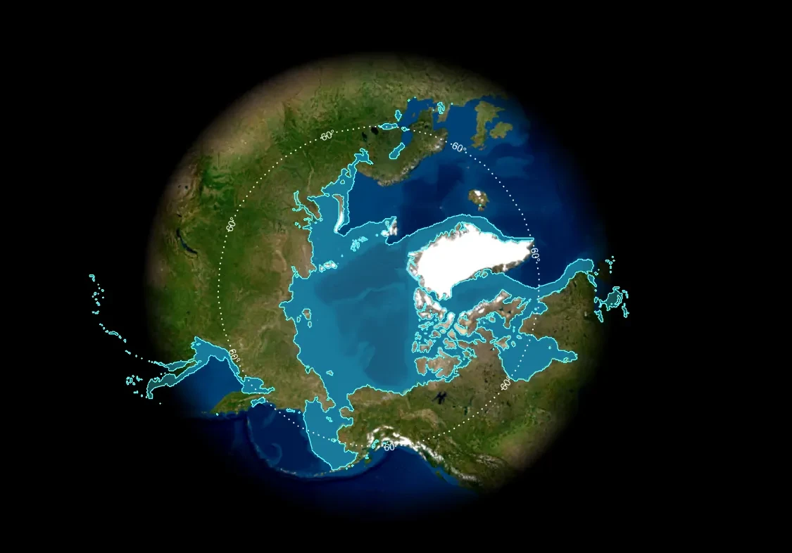
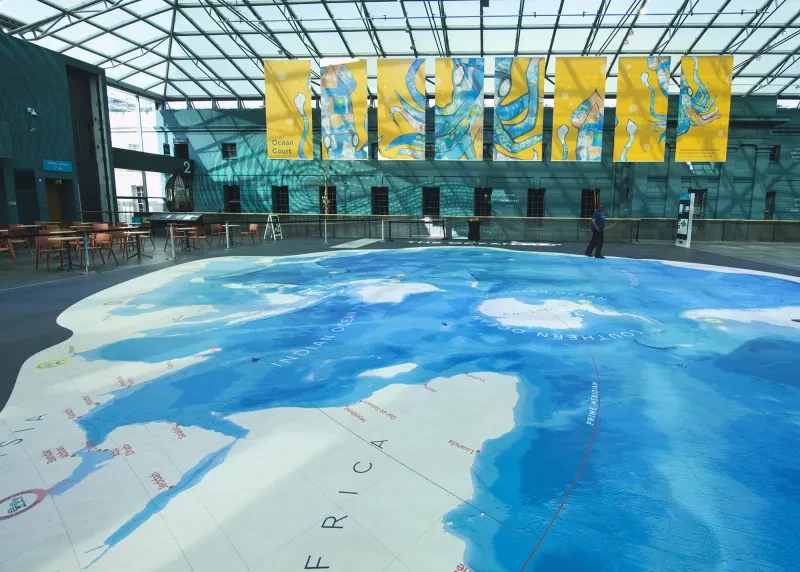
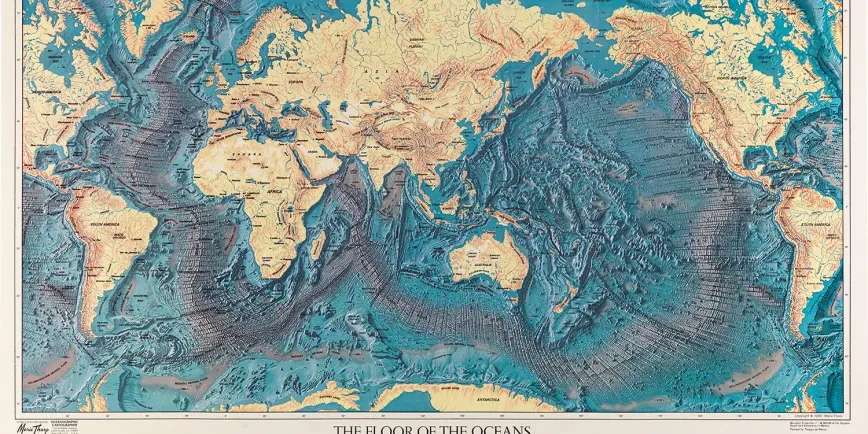
The Ocean Map at the National Maritime Museum is a peculiar way of seeing our planet.
The map uses what is known as a Spilhaus projection to show the ocean as a single connected system rather than separate bodies of water.
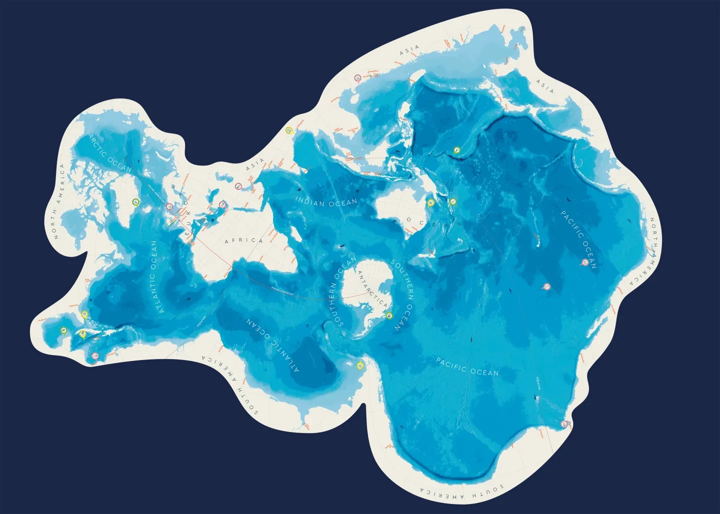
‘Most maps cut through the ocean to see the land more clearly, showing us continents and coastlines in a familiar way,’ writes Aimee Mook in The Ocean Map: exploring our watery world. ‘This map shows us our one big ocean in a more unfamiliar way!’
Seeing the world in this way raises lots of questions. If there is one 'world ocean', how does water move around it? Why are conditions so different in different parts of the ocean, from the icy Arctic to the tropical Pacific? Perhaps most importantly of all, what impacts are we having on the ocean – and how are scientists trying to understand what's happening in this huge blue system?
Introducing ocean currents
Throughout history humans have followed the motion of the ocean. Currents, tides, winds and waves have carried us to every part of the world.
But the ocean doesn’t just carry people. Ocean circulation – the movement of water around the Earth – transfers energy, food, salt and sediments, and influences both our local and global climate.
As wind blows over the open ocean, it drags the top layers of water with it, creating surface currents. These surface currents can combine to form large circular systems called gyres.
Gyres spin in different directions depending on whether they are in the northern or southern hemisphere. This is due to the Coriolis effect, where the rotation of the Earth causes air to be deflected east or west.

'A view of ye general and coasting trade-winds, monsoons or ye shifting trade winds through ye world'
G201:1/38 • Charts & Maps
This chart, published in 1715, indicates prevailing wind directions using arrows and fine engraved lines. Sailing ships made use of these predictable patterns: nautical terms like ‘trade winds’, ‘volta do mar’ (a Portuguese phrase meaning ‘turn of the sea’), the ‘Roaring Forties’ and ‘the doldrums’ all describe the conditions that seafarers encountered in different parts of the world.
Currents don’t just happen at the surface however. Deep ocean currents are also constantly moving water up, down and around our planet thanks to changes in water density – how ‘heavy’ the water is.
Seawater density is affected by temperature (how hot or cold it is) and salinity (how salty it is). Cold, saltier water is heavier and so sinks. Warm surface water gets pulled in to replace the sinking water, creating a cycle. The cold water moves slowly round the Earth before rising to the surface again in a process called upwelling.
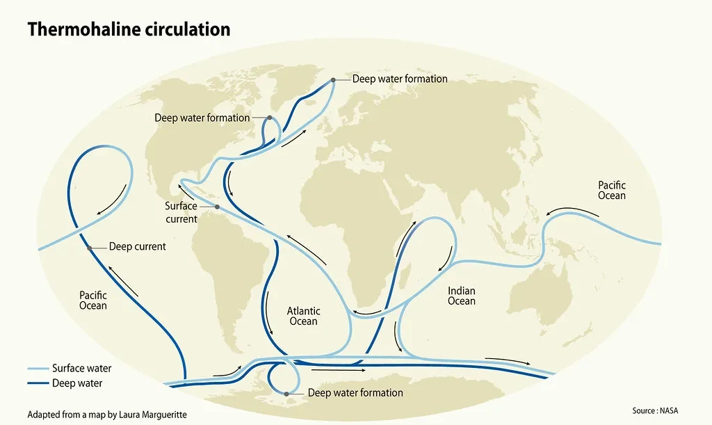
This cycle is sometimes called the global ocean conveyor belt. It is estimated that it would take 1,000 years for a drop of water to complete a full circuit of this global stream.
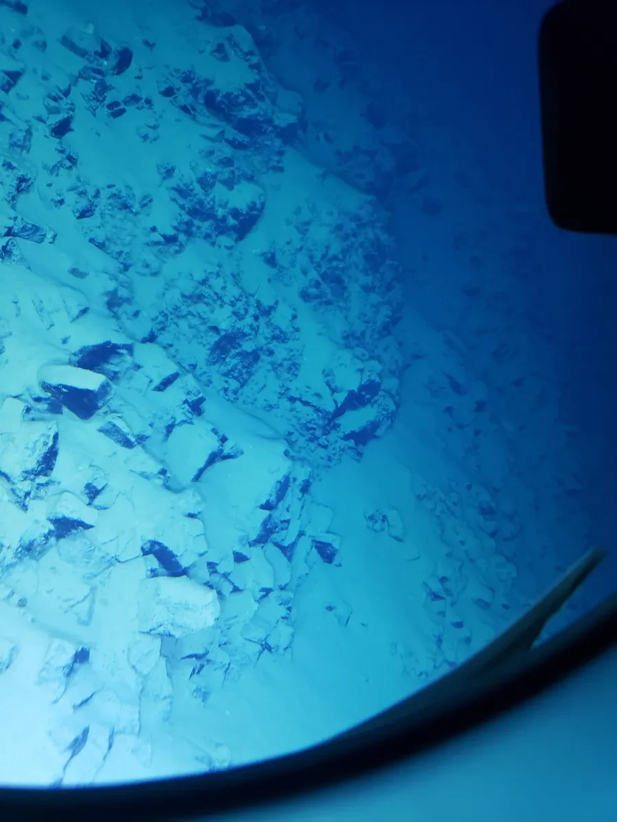
The importance of sea ice
About 15% of the world's ocean is covered by ice for at least part of the year.
Sea ice in the polar regions is vitally important for our planet: it helps keep the global ocean conveyor belt turning, reflects some of the Sun’s rays back into space, and supports the nutrient-rich waters that form the foundation of the marine food chain.
But human-caused climate change is having a dramatic impact on sea ice. Measurements of summer Arctic sea ice extent each year show a shrinkage of 12.2% per decade due to warmer temperatures.
The National Maritime Museum is home to thousands of objects related to polar exploration, including from expeditions searching for the 'Northwest Passage' – an Arctic sea route connecting the Pacific and Atlantic Oceans. Human-caused climate change means that this once almost-impassable sea route is now increasingly ice free during the summer months.
The number of ships operating in the Arctic reached a record high in 2025 according to data from the Arctic Council. More traffic in the region could have serious impacts for indigenous communities and marine life.
Image
Sea Ice Aware
Areas of the ocean that have frozen are considered 'sea ice', and can vary from slushy, barely solid areas to sheets of ice that are meters thick. Since the late 1970s, satellites have been used to monitor both the extent and concentration of sea ice around the world.
This online tool lets you track the extent of sea ice in both the Arctic and Antarctic each month, and explore how it has changed over time.
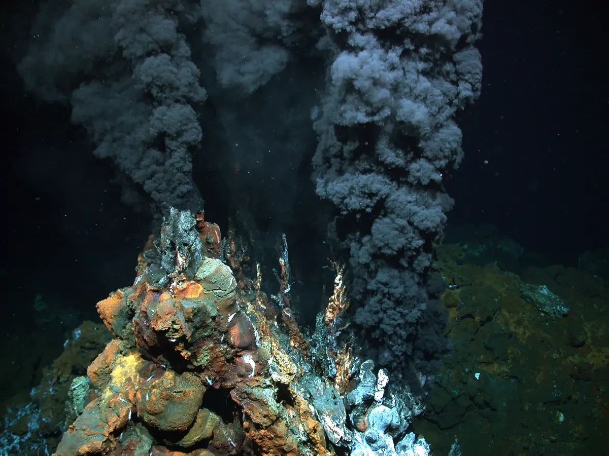
Submarine volcanoes
Volcanoes are openings in the Earth’s crust that allow hot molten rock known as magma to erupt from beneath.
While it's hard to imagine fiery magma spewing out beneath the waves, scientists believe that up to 80% of all the volcanic activity on Earth actually takes place underwater. The film below from the Woods Hole Oceanographic Institution gives some idea of what these submarine volcanoes look like.
‘Underwater volcanoes are unique environments that can teach us a lot about extreme life on Earth, and even the possibility of life on other planets,’ explains curator Aimee Mook in The Ocean Map: exploring our watery world.
Kavachi, named after a fiery sea god from the Solomon Islands, is one of the most active underwater volcanoes on Earth. But, as Mook says, ‘Animals like hammerhead sharks have been found living inside Kavachi, despite the unusually high temperatures and challenging environment.’
Dive into the ocean with the National Maritime Museum


Read more
Our relationship with the sea is changing. Discover how the ocean impacts us – and we impact the ocean – with the National Maritime Museum.


Main image: Karim Iliya / Kogia